
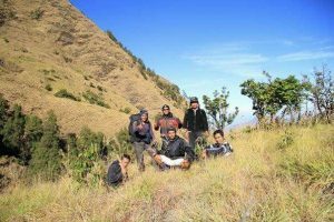
Rinjani via Senaru choice or option, do it’s the best. It would be nice if we first got to know Mount Rinjani. Climbing via Senaru is most commonly used by climbers, to see the most perfect beauty of the crater.
This is the option Rinjani via Senaru choice:
- Rinjani Mountain Trekking 3D/2N (Rim Senaru) via Senaru
- Rinjani Mountain Trekking 4D/3N (Lake) via Senaru
- Rinjani Mountain Trekking 4D/3N (Summit) via Senaru
- Trekking Rinjani Private Package Charge Via Senaru
- IMPORTANT REQUIREMENTS THAT ARE RECOMMENDED TO BRING DURING THE RINJANI MOUNTAIN TREKKING
AT A GLANCE ABOUT MOUNTAIN RINJANI
If you are a true climber, surely you will know Mount Rinjani, the most beautiful mountain in Indonesia, so do not miss it, let know more closely.
Come visit Mount Rinjani via Senaru choice, get the best experience and the most beautiful in your trekking experience. If you want to trek Mount Rinjani you can do it through some climbing access to; Senaru village, Torean village, Sembalun Lawang village, Sajang village, Tetebatu village and Aik Berik village (northern Batukliang) in general.
Most climbers make the climb through access to Rinjani via Senaru choice or Sembalun Lawang village especially for climbers who only want to conquer the Rinjani peak at 3,726 m the closest access is via Sembalun Lawang.
In the near future Central Lombok regency government has a discourse to take part in being involved in organizing the climbing of Mount Rinjani through Central Lombok district practically because it already existed but was not as noisy as the Senaru and Sembalun hiking routes.
Which are geographically located in the regency area North Lombok (Senaru) and East Lombok regency (Sembalun) apparently Central Lombok Regency also does not want to be a constant audience until this plan will be pursued with an innovative concept by planning road construction or opening new lanes.
RINJANI TREKKING PACKAGE VIA SEMBALUN
So that climbers can drive as much as possible near maybe in the mouth of the crater Segara Anak because this is part of the alternative for those who are physically no longer able to climb the terrain such as the Senaru and Sembalun lanes.

Sembalun is the closest access to the trip to the summit, because it means you will start climbing from an altitude of 1,156 m above sea level while climbing through Senaru access starts from an altitude of 601 m above sea level.
Mount Rinjani is the highest number 2 volcano in Indonesia after Mount Kerinci in Jambi (Sumatra) 3,805 m above sea level.
Mount Rinjani has erupted several times and the volcano experts think that Mount Rinjani before erupting was estimated to be about 5,000 meters cone.
After two large eruptions this mountain formed a crater in the middle of a former eruption it resembles a bowl, accommodates rainwater in its crater located in the middle of a rainwater lake called ‘Segara Anak’ lake which is at the elevation level of 2008 m above sea level which has an overflow in the north.
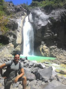
Overflow water from Segara Anak lake forms a small river, the water is white until the local people give the name Kali This is called “kokok Putek” in the sasak language which means white river.
Where the flow of water that comes from the overflow of Segara lake child raises many waterfalls in the flow there are some popular ones to visit, namely: Mangku Sakti Waterfall and Mayung Putek Waterfall (white deer) and Umar Maya waterfall.
Mount Rinjani National Park via Senaru choice
Began to be developed into a tourism industry since 1999 and was followed by the establishment of an RTMB institution (Rinjani Trekking Management Board) which trained and educated all components involved in organizing mount Rinjani climbing.

Mount Rinjani Geo Park erupted for the umpteenth time in 2004, due to this eruption there was no effect caused only by a small boom that was heard up to the city of Mataram and centered on volcanic cones which were confined by the walls of a high crater and the last eruption on November 3, 2015.
For 2 weeks which resulted in disrupted flight traffic, especially at the Ngurah Rai international airport in Bali and Lombok’s international airport (BIL) due to the effects of rain of volcanic ash blown into the air to block visibility for flights.
But ironically for those living in around the slopes of Mount Rinjani there is absolutely no effect from the rain of dust, only those who most clearly hear every boom when an eruption occurs.

The impact of the eruption of Mount Rinjani was enough to have an effect on the tourism actors who felt the impact of the volcanic ash eruption of Gunung Baru Jari because many travel guests agents and hotel canceled their arrival.
Due to flights for the Ngurah Rai international airport route Denpasar (Bali) and Lombok International Airport (BIL) has been temporarily closed, including the climbers of Mount Rinjani, who are definitely tourists who have already paid a down payment for hotel accommodation located on Lombok.
The Gunung Rinjani area is part of a national park consisting of 40 national parks located in the archipelago covering an area of 41,330 ha and also incorporated in a 66,000 ha protected forest with forest conservation and animals protected by the state.
Around the slopes of the mountain Rinjani has 20 traditional villages surrounding it, the crater of Mount Rinjani is formed so beautifully that many mountain lovers come to visit it, in addition to seeing the enchanting nature of the climbers can also do fishing on the Segara Anak lake.

These fish used to come from seeds sown by the second president of the Republic of Indonesia, namely President Suharto, who until now breed to become large sizes.
Especially tilapia fish, climbers as they pleased can fish on this lake but according to information from the anglers of the fish found in this lake are slightly different.
Compared to the fish commonly found in fresh water which are below that these fish have a slightly larger head probably due to lack of food intake until the fish found on the lake are very hungry so anglers are very easy to get and certainly these fish when cooked or when served a little smell of sulfur.

This lake is called Segara Anak lake by Lombok people. It can be guessed from giving the name of this lake that what gives the name is local people (people of Lombok).
In ancient times Lombok people saw water that was as large as when they saw the ocean. “Immediately” as well as Segara Anak lake whose water resembles a small sea of Lombok people call it Segara.
It could be the Lombok people when they saw the lake on the crater of Mount Rinjani resembling a child from the ocean to the name of the sea or “Segara Anak.”

Likewise, the volcanic cone has an elevation of 2,351 m above sea level which is on the edge of a lake named Gunung New finger or New Mountain.
So because Lombok people used to think the volcanic cone was a new or emerging mountain without them knowing that it was the geological effect caused by the pressure of magma which pushes the surface of the earth to form like a cone.
Without ever knowing that the crater was a former eruption that was very powerful, in general 20 years ago Indonesian people had known Mount Rinjani through pictures on paper money worth Rp 10,000

For mount Rinjani climbing activities it has been well organized under the auspices of the RTMB (Rinjani Trekking Management Board).
Where this organization empowers local residents to enjoy the grace of the beauty of the Mount Rinjani National Park that God has given to work as an organizer.
Tour guide and porter around the villages of Senaru and Sembalun, they were trained (porters and guides) on how to treat tourists during the ascent of Mount Rinjani especially how to cook, make European-style dishes because climbers were also mostly (foreign nationals)
The practitioners of climbing Mount Rinjani tourism were trained ways to save, preserve the environment and the surrounding environment, especially to maintain the cleanliness of Mount Rinjani from garbage, especially plastic waste. The packages that we offer for climbing Mount Rinjani are.
