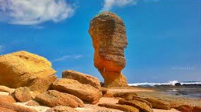
Batu Payung (Umbrella Stone) ? Maybe we do not have to argue about the origin of this name because it is simple to see from the word Batu, which is certainly the form of the intended object and the word Umbrella may already be guessed because of the towering shape of the stone or the word others who experience abrasion for a long period of time until the top of this stone looks bigger than the bottom that supports it to be called Batu Payung.
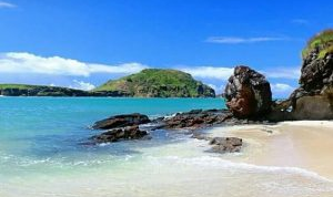
Batu Payung is seen faintly on the tip of the promontory to the east from the top of Merese hill.
Although it is actually not exactly like an umbrella, but this term is easier to use to preserve the shape of this stone, besides that, we can use this stone as umbrella or shelter if the sun is very hot.
In my opinion this stone condition is very dangerous, because of the possibility of broken (it was broken) when viewed from its form which is increasingly eroded by water so that the upper load is unable to be supported by a lumpy part which is at a glance like the form of this fungus.
Alternatively, you can rent this boat without having to walk along the shoreline
This Umbrella Stone is actually popular after appearing on cigarette advertisements which took the location of shooting in Tanjung Aan which featured a beautiful appearance at a glance taken from Drown cameras until now Batu Payung has become the target of domestic tourists.
Foreign tourists and especially local visitors or Lombok people. accessing the coastal path to get to the location of the stone form of this umbrella can we also see from the top of Merese hill or from the top of the hill to the right or west which seems vague but the shape can still be recognized.
In addition, we can also visit by renting a boat at Tanjung Aan bay with a rent of IDR 250,000 for the cost of commuting with a suitable capacity to fill a boat that can be estimated at 10 people because the boat is not too big and takes 10 minutes, it is not difficult to get this service if you roam and look foreign around Tanjung Aan, there will be people who come to offer crossing services to the location of Batu Payung.
Batu Payung is located behind a hill or at the end of a hill that appears to be smearing into the sea
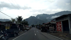
This beach is located not too far from Kuta beach about 5 km to the east along the beach with asphalt road which is rough and only 3.5 meters wide with a sequence across Seger beach, Tanjung Aan bay.
Then Batu Umbrella beach which is not visible from the asphalt road because the location of the mo mental stone is behind the rocky hill, to get to this path there are no signs given on the roadside.
From Tanjung Bay, you can see Batu Payung at the left end
To approach this, only the people around us can ask, but there are very few local people who flash, there are only traits of 4-wheeled ex-road that cut dry land that resembles a path to a fisherman’s hut and occasionally there are promotional banners or hotel advertisements.
Now here will be a young man who welcomes you while offering a parking ticket of Rp 5,000 for a motorcycle and Rp 10,000 for a 4-wheeled vehicle. From this parking lot, the Batu Payung object does not appear only when we ask the parking attendant with only a simple answer. pointing to the direction of the rocky and rocky coastline, while saying “there is a little way to go 1,5 km there”
We can see Batu Payung from above if we come across the top of the hill
To get to Batu Payung location, you need to be careful because you will cross slippery rock rocks because at certain times the tide causes moss on the surface of the rock, approximately after walking 10 minutes you will see Batu Umbrella as shown.
Besides, there is an alternative way up the hill but later when going down it will be a little difficult to spin a little but this is a better alternative than having to wet your feet while dragging drag to avoid the slippery parts and be careful also because there are sharp pieces of rock eroded by the waves.
No Other alternative places for shelter if the weather is very hot except only on the part of the rock that we visit, there is nothing special in this location only if for shooting it looks very unique because rarely do you know that there are stones like that but for me this form is more correct to call it rock clothes that still have hard earth elements.
From Gerbang Wisata to Batu Payung beach 1 hour 25 minute (60 km)
You can get cano rental locations on the east side of Trawangan Gili Islands
Canoeing on Gili Trawangan is not very regular, we see it only a few times when people pass by canoe either because of what, but usually this activity is often seen when the sea water conditions are calm again.
Maybe because of that reason, so seldom people canoe on Gili Trawangan but also hearing from tourists he said rental prices were too expensive.
There are two canoes which we commonly see, namely canoes for single and double canoes facilitated with paddles and jacket lifts or life jackets, the rental costs are calculated on an hourly basis.
But what is certain is the location for canoe play spots on Gili Trawangan you can get around the location of turtle breeding sites or in front of the Oda cafe which is located next to the north east coast of Gili Trawangan island or about 1 km to the north from the public port, there some canoe fruit will appear on display by propping on pine trees but this is mainly the type of puddle board while the canoe is placed on the beach.
the atmosphere of the east side of the island of Gili Trawangan, while relaxing the others while playing Cano
If you want to rent enough, you stand near the display items, then someone will come to greet you because canoe guards usually relax watching the canoe from under the spruce or in the surrounding stalls without even having to come near the canoe.
The tenants usually greet while offering rentals , but there is no price list installed at a glance, I heard that for the rental price of 150,000 / hour, the form of canoe which we commonly see here is mostly like surf boards (puddle board) but the size is very large which is facilitated with other forms of temporary paddles and life jackets there are also like canoes in general.
At first glance, it seems that most Caucasians, who are more rented compared to domestic tourists, are probably Indonesian people, most of them are afraid of black skin times? Caucasians and Caucasians enjoy this game more often they are seen standing how to use it.
While holding it in the middle, especially the transparent ones, Caucasians and Caucasians standing on the board wearing bikini clothes and rowing, there was a faint look at a rope attached to the ankle so that when the board was turned upside down or fell not far away it ran because the rope was tied ankle, the price can also change if the visit season is quiet if this problem please just bargain the price later.
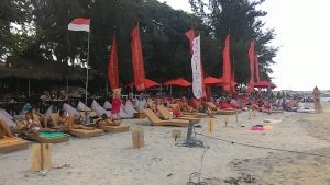
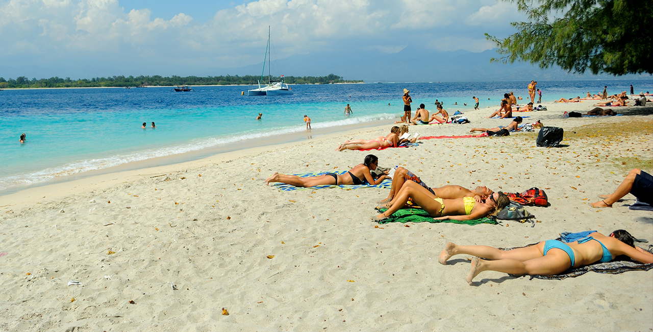
As a true traveler, wherever you want to visit wherever possible, every moment you want is recorded, at least it can be recorded by the picture of your smart phone right? No exception if you are going to visit Gili Trawangan surely you want to show that you really are on Gili Trawangan with the characteristics there are Caucasians and Caucasians again basking on the beach.
Location in front of Ombak Sunset Hotel
Well, the sunbathing location on Gili Trawangan is generally seen in front of the Horizontal pub lounge which is about 300 meters from the public port on Gili Trawangan, walking to the right because in this area it has a vast expanse of white sand, Caucasians who want to embezzle the color of the skin is where they are basking in bikini clothing to sleep on their backs while reading thick novels using a glass sun or we call black glasses.
Almost most of the sunbathers here are western or for Indonesians we call Caucasians because the color of the skin is white, if there are local or indigenous people who join here it will look strange, for Caucasians to darken the skin is their tradition while on vacation to the tropics which is sometimes their pride as a sign of returning home from the tropics because Europeans enjoy less sunlight than people who live close to the equator.
Sunbathing location on the east coast of Gili Trawangan in front of turtle breeding
Sunbathing in mini clothes for Caucasians and Caucasians is a tradition of their culture in vacation, walking in bikini clothes even when paddling a few times, but don’t get mistaken that doesn’t mean this is porn action but this is a matter of tradition and does not mean Caucasians are free to be touched because of their way or their meteoric culture, it is not for them a bitch or porn is part of their lifestyle.
When they dress like that they will be very disturbed if you glare at it especially if you dare to touch an unnatural part of the body, the Caucasians will report you to the authorities. For now the tourist visit to Gili Trawangan is very swollen in the area that I mentioned above has been unable to accommodate so many people who will bask in front of Horizon pub so now in the place I mentioned it is no longer playing set.
On the west coast of Gili Trawangan beach many foreign tourists are sunbathing sporadically, especially now that all the buildings on the beach are evicted by the district government apparatus, more and more areas are considered comfortable to relax or sunbathe, unlike before if you just sit there suddenly will come to offer food menus at quite fantastic prices.
Sunbathing location on the North coast of Gili Trawangan in front of the Bali Kana hotel.
On Gili Trawangan, although it is the largest tourism destination in the archipelago, it does not mean that Caucasians and foreigners have the freedom to carry their customs and traditions to this island because they are very good and the values of social norms are still highly valued on this island. Caucasians are limited not to wander haphazardly into the village by wearing their bikinis because in every alley and entrance, a warning has been given with the prohibition against using bikini clothing into the village.
Previously the coast was dominated by business people so it did not provide space for people who just wanted to sunbathe.
Only they are given the flexibility at the beach side location, of course, especially for naked naked without clothes they are already in the path with writing on the sunbathing location not to be naked and must respect the norms of the local community especially now that it has been standing for a long time 2 mosques are quite large and wrong one is quite magnificent with modern architecture.
Likewise, in Lombok there is a landmark building which is a building of a mosque that is being built very large (Lombok Landmark) which has been running from 2009 until now is still in the process of approximately 75% physical construction.
Which seems to have finished the construction phase of the dome and several towers because this mosque will be facilitated by the construction of the university which is one in the mosque’s courtyard.
The construction of this mosque is located in the heart of Mataram which is well known by the nickname 1,000 mosques and mosques which are the mains of mosques in Lombok and the names are not mentioned as other mosques are simply called “ISLAMIC CENTER MOSQUE” of course if In terms of the name.
This mosque will be of international standard and surely the students who will study at this university will consist of students from abroad. But recently there is another name besides the Islamic Center, the Great Hubbul Watahan mosque which means Love of the Motherland.
The construction of this mosque is Lombok Landmark sure to engulf the NTB provincial government budget because at the stage of construction it frees KONI Field, Mataram 6 Junior High School, the plantation office, the fisheries office and will follow the market of Dasan Agung Village which is still active as usual. northward. Udayana, eastward Jln. Pejanggik, to the south. Erlangga and to the west Jln. Langko the position of this mosque is located on the corner between Udayana and Langko roads.
This mosque is Lombok Landmark, The initiator of the construction of this mosque is the Governor of West Nusa Tenggara (NTB) Dr. KH. Muhammad Zainul Majdi M.A. or better known as TGB (Tuan Guru Bajang) Pouring Teachers in Lombok means that Kiyai and Bajang means that in Lombok language is young, which has taken office since September 8, 2008 until now.
It was the second term of office and his representative in the first period was Mr. Ir. Badrul Munir period (2008 – 2013) the figure of the governor was the grandson of the founding figure NW (Nahdatul Waton) of the great or famous cleric in Lombok. TGH. M. Zainuddin Abdul Madjid, as governor who graduated in Egypt.
Took part in politics from the Bulan Bintang party and finally moved to the Democratic party which is still in office, the second period representative is Ir. Muhammad Amin and once received the title of the youngest governor in Indonesia who was elected since the age of 36 year old
The source of funds for financing the construction of the Islamic Center mosque also involved donations from the salaries of civil servants in the NTB province cut shortly as participation in charity, worship and building for the benefit of the community because the majority of almost 90% of the population of NTB province are Muslims.
Who has a characteristic lifestyle of people who are very religious to the island of Lombok is well known by the nickname 1,000 mosques because it is proven when you arrive in Lombok you will find many mosques lined up along the road with a distance that is close to the physical building which is very large on average, then how to can this be the case?
You may insert tour package to visit this place, just find out here OUR SERVICE OFFER
In Lombok, the community prioritizes mosque buildings rather than house buildings, even though the income of the per person community is still relatively low compared to other areas and it is highly unethical by the rich people.
To build houses higher than mosque buildings, you can see a thousand mosque monuments when you Lombok airport drives to the city of Mataram where it is exactly at the intersection of a statue of a cow in Gerung sub-district, West Lombok district, right in the middle of the roundabout.
Recently on July 30 2016 Hubbul Wathan mosqe was trusted as the venue for the 26th national MTQ and this series of grand events was opened by President Joko Widodo and of course this atmosphere was very warmly welcomed by the people of Lombok in particular and by the people of NTB In general.
The presence of caravans from various regions greatly made the atmosphere of Mataram city suddenly colored and the committee had anticipated everything to avoid congestion so that the implementation of MTQ was as expected.
Until finally the implementation was successful because there were no obstacles and symptoms that we did not want, implementation the competition consists of many categories but sorry the details I do not understand for that if you want to know more please ask Google.
The mosque building consists of a 3-store core building, the first floor is a 4-wheeled vehicle parking space, the second floor is for the pilgrims’ room and the top floor is for women worshipers.
There are two escalators connecting the first floor to the third floor. Tiong Hoa ethnic Muslims outside the core courtyard, in addition to the core courtyard there is a page of mosque which is 2 meters higher than the outside courtyard of the mosque.
There are 5 mosque towers, one of which is the highest located in the middle of the 99 meter high entrance as a symbol of “Asmaulhusna, location The highest tower is used for religious tourism.
Visitors can enter the tower by paying Rp. 5,000 / person for a ride using the elevator donated by the Batu Hijau gold mining company on Sumbawa island PT. New Month other than that the building consists of a landscape courtyard which is part of the garden which is in the process of paving and arranging flowers and there is a fountain in the corner of the building.
Sembalun valley District geographically has its own uniqueness which is located at an altitude not far from the slopes of Mount Rinjani on the Sembalun valley surrounded by rocky hills which are overgrown with shrubs and grasses with altitudes of up to thousands of meters.
The Sembalun land is at an elevation between 800 m elevation – 1,100 m elevation that enters in the area of East Lombok regency with an area of 217.8 sq km and an estimated population of around 20,000 people quoted from Wikipedia which is less than 100 km from the city of Mataram if we come from the direction of Central Lombok district.
sembalun valley district
Looks like the Pergasingan hill from the main road
Previously Sembalun sub-district was still part of Aikmel sub-district, East Lombok district, but after the area Expansion occurred, Sembalun had become a sub-district directly adjacent to North Lombok regency, Bayan sub district, separated by streams formed by overflowing lakes “Fresh Children” in the crater of Mount Rinjani which formed several waterfalls which are now the target of travelers.
Rinjani from Lelongken hamlet, Sajang village of Sembalun
Visitors mostly from Mataram city residents or Lombok residents in particular and the traveler archipelago in general are: Penimbung waterfall, Mangku Sakti waterfall, Mangku Kodek waterfall, Kuda Sembrani waterfall, Mayung Putek waterfall, Madu waterfall, Umar waterfall Maya and will follow the new names again considering this can happen after many visitors come and names will be made soon, a series of waterfalls are in the village of Sajang and the village of Bilok Petung, Sembalun district.
Sembalun Sub district from the top of the Pergasingan hill
Sembalun has a flat land contour and is walled by steep rocky hills that are overgrown with green grass and the plain below is a very fertile rice field which is generally planted with tubers such as potatoes, carrots, sweet potatoes and others. Also grains such as corn, beans, winged beans and others, tomato vegetables and others are very fertile on this land, especially this location was once known as a producer of garlic and shallots until later on the main road you can see a 5 meter high garlic monument.
Village In sembalun Valley district
Sembalun Sub district consists of several villages which have recently been expanded up to 6 villages namely: Sembalun Bumbung village, Sembalun village, Timbak Gading village, Sembalun Lawang village, Sajang village and the northernmost village of Bilok Petung or bordering the sea and its plain lowest.
Mangku sakti Waterfall in Sajang village
Sembalun has a vast savanna that ends at the foot of the slopes of Mount Rinjani, some of this land is used as a land for agribusiness projects that appear strikingly visible in the village of Sembalun Lawang with its many transparent tents or green houses lined up to cover hundreds of hectares.
Administered by PT. Sampoerna and now the local people call it the SKE project without them knowing the abbreviation of the abbreviation SKE (Sembalun Kesuna Emas) “kesuna in the Sasak language, the meaning of garlic.
Mount Rinjani from the Selong hill in Sembalun
As for commodities from agro-business, this is a superior crop that is not commonly grown on land in general, including: melon plants, strawberry, apples and root tubers such as potatoes, carrots and tree tubers such as eggplants, tomatoes, paprika and others.
This project is supported by an irrigation system that is obtained from groundwater by being pumped with a well bore support system and placed like a pool of stagnant water such as a pond which is very striking if we look from above the Rinjani climbing court via Sembalun.
Pergasingan hill Sloop
Sembalun now appears to be progressing step by step since it was made as the entrance to mount Rinjani climbing which has stood for a long time and has an office as a place to register and reserve every climber who wants to do trekking to the summit of Mount Rinjani or travel to Segara Anak lake.
Hotel in sembalun Valley
Already many of the hotels built are even one-star “Pesona Rinjani” just on the main road which is only 3.5 meters wide and facing towards Mount Rinjani.
Not far from there Rudy ’s is in the process of working and is about to finish, Sembalun Agro villa, Rinjani Garden, Lembah Rinjani, Nauli Bungalow (long time) Rinjani Family and even the old ones like Cemarasiu and many more and there are also lodging which costs under 100,000 / night.
Almost all lodging is located in Sembalun valley between Sembalun Lawang and Sembalun Bumbung which are sporadically separated. Besides that there are now many ATM units that are spread between Sembalun Bumbung and Sembalun Lawang, there are already BNI ATMs in several places, Mandiri ATMs and BRI ATMs which are located not far from the Rinjani Geo park gate.
Expanse of rice fields from Bukit Selong
As for other interesting things in Sembalun sub-district apart from the cold temperatures because it is at an altitude are the hills around it which surround the valley of Sembalun sub-district.
Which is currently very regularly visited especially every school holiday by young Lombok people who adventurous including there are some access to go up to the surrounding hills, namely: Pergasingan hill, Selong hill, Nanggi hill, Anak Dara hill, Dandaun hill and Berugak hill.
Looks at the Selong hill and the peak is the Anak Dara hill
All of these hills are now the object of camping ground location or camping location and if you want to be more special, you can organize camping trips in this location so you don’t have to bother carrying camping equipment.
Everything is provided, you just need energy to go up to up the hill up to 2.5 hours of climbing to get to the top of Pergasingan hill for example with an altitude of 1,700 m Elevation and can enjoy the coolness of the cold night befriend flashing stars above the sky.
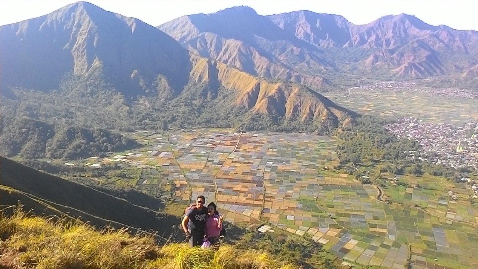
Towards the morning on these hills we will be able to see the exoticism of the sun’s rays illuminating the valley of Sembalun from above the altitude seen by the houses in groups.
Especially the rice fields that look very unique in the form of boxes like green, yellow and brown carpet which is currently busy posted on Instagram and Facebook by nature lovers from outside the Lombok region.
Settlers in Sembalun have not been able to compensate for the smooth construction of the current asphalt road
As for the development at the end of 2017 the paving work for cross section has been widened by a width of 6 meters with road markings that are still very new, traffic signs strongly support the widening of this road.
The quality of pavement is inversely proportional to the conditions of settlers on the sidewalk, quality road violence is not inferior to the district capital.
There are only a lot of large domed mosques that are able to match the quality of this road violence, unfortunately this wide road violence can only temporarily reach Sembalun Lawang not yet reached Sajang and Bilok Petung villages, it seems all the roads in Sembalun sub-district will be the same, just waiting for the APBD budget to be able to continue.
Pergasingan hill from the Selong hill
Besides that, the gate to Sembalun, Pusuk Pass, is in the process of clamping the cliffs with a very large volume of excavation because this work is forced to dig very high cliffs.
Landslides are very frequent in this location and very often close the road during the rainy season. in addition.
The road packing work can increase the width of the road from the previous one which is very narrow, which is certain until now there has never been a bus with a capacity of 25 passengers that can pass at this location, because the road is very narrow and the incline is too steep.
Recently happened, this morning on July 29, 2018, the 6.4 SR earthquake in Sembalun centered in North Lombok which claimed 2 victims in Sembalun one of them was Malaysian while in another place in Sambelia sub-district there were 10 victims.
On Mount Rinjani on the lake “Segara Anak” an ongoing evacuation of rescue climbers is estimated to number 300 people trapped by landslides due to the effects of shaking to accumulate a closed climbing trail.
TEMPORARY PARAMETERS AS FOLLOWS:
Strength: 6.4 SR
Date: 29-Jul-2018
Earthquake Time: 05:47:39 WIB
Latitude: 8.26 LS
Longitude: 116.55 BT
Depth: 10 Km
Location:
Sumbawa Region, Indonesia
Information:
28 km Northwest LOMBOKTIMUR-NTB
32 km Northeast LOMBOKUTARA-NTB
57 km Northeast LOMBOKTENGAH-NTB
61 km Northeast MATARAM-NTB
1105 km southeast of JAKARTA-INDONESIA
Tsunami Information:
This earthquake is potentially TSUNAMI in BALIKPAPAN
DATA OF VICTIMS RIVER IN SEGARA LAKE, CHILDREN OF MOUNTAIN RINJANI.
Progress related to Earthquake in Kec. Sembalun Kab. Lotim causes visitors to get stuck on Mount Rinjani.
Facts:
On Sunday 29 July 2018 at 24.00 at the Sembalun sub-district office, a coordination meeting was held attended by:
– Forkompimda Lotim
– Forkompinca Sembalun
– Head of Tourism of NTB
– Head of BPBD NTB
– Basarnas
– Porter’s representative
Discussing include:
– Post-earthquake handling
– Evacuation plan of the climbers who are still in the position of Pelawangan G.rinjani KM 10 around 500 people and one of the MD climbers in Pelawangan an. Muhamad Ainul Taksim A, 26 years old, Student of Makassar address.
– Evacuation plan start at 8:00 a.m.
– Basarnas team involvement, TNI-Polri, Porter and Medical Team.
At 24:05 local time at Balenta Sembalun Outdoor Sembalun Village, Kec. Sembalun Kab. Lotim has checked the Mount Rinjani Visitor Register Book by TNGR officers with the results of the total calculation of TNGR officers as many as 524 people (358 foreigners + Indonesian citizen 166 people):
Foreigners include:
Visitors from Malaysia are 21 people
Visitors from France are 35 people
Visitors from the Netherlands 23 people
Visitors from Thailand are 174 people
Visitors from India are 5 people
Visitors from Singapore are 5 people
Visitors from Italy are 3 people
Visitors from U.K Country 6 people
Visitors from USA Country 5 people
Visitors from Spain are 5 people
Visitors from Belgium are 7 people
Visitors from Switzerland are 13 people
Visitors from China are 7 people
Visitors from Canada are 8 people
Visitors from Denmark are 4 people
Visitors from Sweden are 2 people
Visitors from Australia are 2 people
Visitors from Croatia are 1 person
A visitor from Myanmar is 1 person
Visitors from Germany are 13 people
Visitors from Austria are 5 people
Visitors from Japan are 2 policemen 2 people
Visitors from Bahrain State 1 person
Visitors from Pakistan are 1 person
Indonesian citizens include:
Visitors from Jakarta 15 people
Visitors from Malang are 2 people
Visitors from Probolinggo 4 people
Visitors from Banyuwangi 1 person
Visitors from Cirebon are 1 person
Visitors from Tangerang 2 people
Visitors from Jombang 1 person
Visitors from Cilegon 1 person
Visitors from Gresik 2 people
Visitors from Solo are 4 people
Visitors from Aik Beriq 1 person
Visitors from Mataram 2 people
Visitors from Loft 1 person
Visitors from Lingsar 1 person
Visitors from Janapria 1 person
Visitors from KLU 4 people
Visitors from Lotim 5 people
Visitors from Lombok are 12 people
Visitors who do not fill in the Register nine (9) people
On Monday 30th July 2018 an evacuation will be carried out from the TNI, Police, Volunteers against visitors who are still trapped above Mount Rinjani, who are trapped around 500 people (at Segara Anak Lake and Pelawangan). Due to a landslide that covered the access road to take it down
The entrance to Mount Rinjani is:
The entrance of Senaru Village, Kec. Bayan Kab. Lotim
The entrance to Sembalun Village, Kec. Sembalun Kab. Lotim
Entrance to Timba Nuh Village, Tete Batu Village, Kec. Sikur ab. Lotim
Entrance to AIK berik Kec. Batu Kliang Utara Kab. Attic
Entrance to Loloan Torean Village, Kec. Bayan Kab. Lotim (Unofficial Line)
Note:
At the Joint Command Post the TNI, Polri, TNGR, Mataram City Hospital Health Team 4 people, Blue Island Medical. Clinic 7 people, Unram Hospital 3 people, Provincial Health Dikes 3 people, Volunteers and tomorrow on Monday establish a Health Post in Post II.
From the information of visitors who have dropped off Mount Rinjani, above 500 people were trapped (at Segara Anak Lake and Pelawangan Lake). Due to an avalanche that covers the access road to go down.
As of Sunday, 29 July 2018, the climbing of Mount Rinjani is closed, and subsequently on Monday, 30 July 2018, an evacuation will be carried out from the TNI, Police, Volunteers against visitors who are still trapped above Mount Rinjani.


 The construction of this mosque is Lombok Landmark sure to engulf the NTB provincial government budget because at the stage of construction it frees KONI Field, Mataram 6 Junior High School, the plantation office, the fisheries office and will follow the market of Dasan Agung Village which is still active as usual. northward. Udayana, eastward Jln. Pejanggik, to the south. Erlangga and to the west Jln. Langko the position of this mosque is located on the corner between Udayana and Langko roads.
 The source of funds for financing the construction of the Islamic Center mosque also involved donations from the salaries of civil servants in the NTB province cut shortly as participation in charity, worship and building for the benefit of the community because the majority of almost 90% of the population of NTB province are Muslims.
 Recently on July 30 2016 Hubbul Wathan mosqe was trusted as the venue for the 26th national MTQ and this series of grand events was opened by President Joko Widodo and of course this atmosphere was very warmly welcomed by the people of Lombok in particular and by the people of NTB In general.
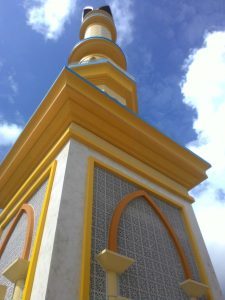 The mosque building consists of a 3-store core building, the first floor is a 4-wheeled vehicle parking space, the second floor is for the pilgrims’ room and the top floor is for women worshipers.