Mangku Sakti Waterfall In Sajang Village Of Sembalun

Mangku Sakti fall

Mangku Sakti Waterfall

Mangku Sakti fall lately is no stranger to travelers, not least among domestic tourists and even many tourists from Malaysia and Singapore who know it, this waterfall is located in Sajang village, Sembalun sub-district, East Lombok district.

Mangku Sakti fall has recently been popular to be visited by young people of Lombok because previously the location was only known by the local community.

From the asphalt road located very far around we walked more than 1 hour to reach the location, when I first visited there was no access the road only resembles a former footpath and crosses large rocks about 300 m2.

When it happened to be drizzling causing the surface of the rock to become slippery and had fallen slipped because the surface of the stone was soaked by raindrops delivered by a friend who happened to he now lives and farms in the village of Sajang.

Waterfall in Sembalun
Mangku Sakti fall in Sajang village Sembalun sub-district, East Lombok

When meet my friend, before being escorted to the waterfall, I first chatted while enjoying a coffee dish from the surrounding garden plants planted by Mr. Garti (my friend) coffee-coffee while asking each other as long as we never met, about a year ago I had searched for it but at that time he went to Sumatra to migrate.

He said working on an oil palm plantation, not long after he offered me to visit a waterfall that was quite far about a journey of more than an hour by breaking through the plantation and forests, this offer is certainly very interesting for me because it is very concerned with my profession as a tourism actor.

Not long after we packed up and I saw “the friend pinned a sharp machete at the waist, I asked spontaneously for what to bring a machete? He just said who knew on the way we met the deer boy later.

Wow in my heart I said this must be a trip which is very interesting but immediately I thought what if we did not find a deer or a deer and instead met with a snake piton, wow that would be very terrible because I am indeed a phobia with snakes.

Mr. Garti
My friend Pak Garti or Amaq Feby with his son Dani

On the way to the waterfall by crossing the coffee, clove, jack fruit, coconut and other plantations and then crossing the forest consisting of wood trees that I did not know his name and once in a while my friend drew his machete to cut wood branches.

That obstructs the path we are passing and in fact it resembles a former footrest but one that is not too often trodden by people passing by here.

Which is certainly in addition to crossing the terrain bushes the road is so difficult with a slope of approximately 20 degrees (very tiring) for sure we bring water to drink.

Approximately after we came out of the wooded trees and found a field consisting of weeds from here the location of the waterfall was near and from a distance there was a roar of water flowing from the rocky crevices, and at that time I asked the name this waterfall.

My friend said his name was “Montong Kaliaga” Montong means baldness and Kaliaga was the name of many wooden trees around the waterfall and my friend said it was only this month the group of East Lombok regents had visited the location of the waterfall.

The discourse of this waterfall will soon be made road access and will be promoted to become the destination of waterfall attractions.

mangku kodeq fall
Mangku Kodek, kodek means is small

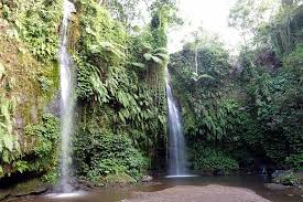
In this trip we did not find a snake or Piton snake which must have been very tiring, sweaty and had been paid for by seeing the Montong Kaliaga fall, which had a slightly different appearance than what I normally see, which is usually clear but Montong. tend to be whitish like water that we usually see coming out of the cracks of rocks in mountainous areas.

The source of this waterfall is abundant water from the crater of Segara Anak lake which is a canal leading to the flow of Kokok Putek, I could ask if we take a shower at the waterfall this friend of mine said yes it’s okay if you don’t take a shower when it rains again he says.

Later on from the top source of the top waterfall there is often rock material which is washed away by the flow of water, God imagine what will happen with your head.

savana in sajang
The path to the Mangku Sakti Waterfall is not friendly

After about a year later several times I passed in the village of Sajang and for the last time there was a sign on the entrance gate that resembled a dirt road.

Could be traversed by a 4-wheeled vehicle where it was written the MANGKU SAKTI Waterfall with finil along with pictures of the waterfall then I am sure that what is meant is the Montong Kaliaga waterfall.

Which has now been renamed the Mangku Sakti, so I really feel like knowing the real path to the waterfall by inviting the same friends to us to try the path together. the new one and according to my friend’s information now access to the waterfall has been organized, to get to the location visitors will be charged an entrance fee and parking fees.

After getting ready to make the 2nd visit, we first bought bottles of bottled water that cost the same as we bought in Mataram because my friend told him last time to the waterfall when we went together he said he was- also seemed enthusiastic to explore the main route to the Mangku Sakti waterfall.

Then we headed to a house that resembled the place where people register and information, but unfortunately the answer we got was unsatisfying because the people in the house were chatting again in terrace and just said just come right there now they were at the location repairing the road to the waterfall.

savana in sajang
Motorcycle taxi to Mangku Sakti waterfall

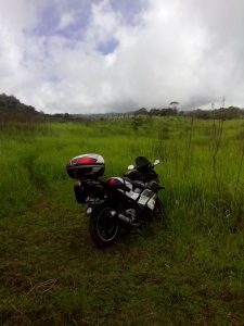
Without much thought, we immediately stepped on the gas along the partly rocky dirt road – this sedan vehicle could not be traversed but if for the Avanza or Xenia type it could still be up to 1.5 km on the way in about 1 km to the direction of the waterfall we saw the residents building mostly architecture houses in Bali and there were places to put food in front of the yard which meant this village was a Hindu religion.

After that it resembled a slippery dirt road and was a little bumpy but a left view the right really makes anyone be fascinated, here I also kept forcing to get to the location but in the middle of the trip met someone who was repairing the road and they advised me to replace the motorcycle he said dear sir the motorbike does not fit this field he said.

ojek transport
Motorcycle taxi to Mangku Sakti waterfall

Finally I parked the motorbike at the hut house and replaced it with a rented motorbike that was ready to be damaged or ready to fall because the condition of the motorbike was just alive and the fish had often fallen also seen from its appearance, we continued on along the muddy, rocky road , bumpy and lots of holes.

Must be extra careful and occasionally when the engine can die because it is not strong enough to compete with the terrain that we went through until we arrived at the parking lot there was already a transit station and met several visitors who were lying there looking tired face.

From the motorbike parking lot we still have to walk again about 15 minutes to go to the waterfall by crossing the path which is a little steep and slippery because the water flows from the remnants of the ground wall that we passed.

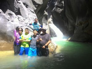
About 10 the minute we were able to get out of the woods and be greeted by a view of the grassland which was then not far from the river lip.

mangku sakti fall
Mangkun Sakti Waterfall

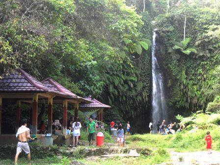
As soon as you arrive at the location, you can see the Mangku Sakti falls and to get closer to that direction we have to walk along the big rocky river bank which is sure the beauty of this place is not only located in the waterfall.

Visitors will be presented with views around Mangku Sakti fall . Again, I have to ask about the previous name change to become Mangku Sakti waterfall, the reason is simply because around the waterfall there is a group of Mangku families who are considered influential in the place.

Mangku in the local language can be interpreted as equivalent to the traditional leader or head tribes that do have a hereditary inheritance to be Mangku in that place, and its purpose is to have kanuragan knowledge or knowledge that can dispel magical powers.

post mangku sakti
Post on the location of the parking lot as well as the rest area

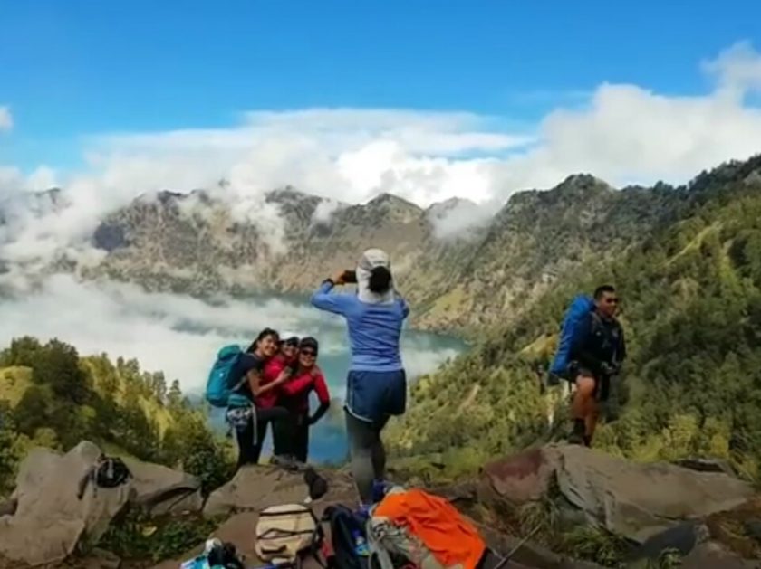
When we headed back to the parking lot we had a chance to talk with the manager that currently the manager is working on 20 horses as a means of transportation to post 2 for climbing Mount Rinjani because from here it is also a climbing gate to Mount Rinjani.

With transport this horse can only deliver until post 3 including some of the horses will be operated for visitors who want to go to Mangku Sakti fall.

Recently Mangku Sakti has been visited by celebrities of the German blooded miss Universe of 2006 who has just been edited by fellow soap opera artist Dimas Anggara. Nadine Candrawinata, a tall, beautiful woman, is certainly beautiful who loves adventure-style traveling for shooting.

Location of Mangku Kodeq Waterfall In Sajang Village of Sembalun

mangku kodeq fall

Mangku Kodeq

Mangku Kodeq fall is located in Sembalun Sub district, Sajang village, which is 106 km from the city of Mataram through the crossing of North Lombok regency or even through the crossing of Central Lombok regency.

Why is it that it is equally 106 km away? because this was intentionally I once measured it through Speed ​​meter on the motorbike that I used turned out by going through the main road (provincial road) crowded lane with heavy traffic from the city of Mataram.

To the east through West Lombok, Central Lombok and East Lombok Regencies (Masbagik, Aik Mel, Lemor Tourism and Pesugulan to arrive in Sembalun sub-district) exactly up to the Gate Welcome to the location of the Mangku Sakti waterfall Speed ​​meter shows 106 km. then if you go north (Mataram, Pass, Winner, Tanjung, Bayan and end at the gate while coming) Speed ​​meter will show 106 km if you are not sure you can try it later?

Mangku Sakti Fall
Mangku sakti Waterfall in Sajang village

Why did I mention the Mangku Sakti Waterfall gate? because the location of the Mangku Kodeq is still one gate with the magical Mangku Sakti waterfall which is still a stream of Segara Anak lake overflowing in the crater of Mount Rinjani at an altitude of 2,000 m.

The flow of water from the overflow of Segara Lake The child forms a small river whose water flow culminating in the sea estuary on the north side of the island of Lombok.

It’s forming a number of beautiful waterfalls including waterfalls: Penimbung, Mangku Sakti, Mangku Kodeq fall, Kuda Semberani, Mayung Putek, Honey and Umar Maya waterfalls until there will be new objects that will following from the continuation of Segara Anak lake water.

The color of the water is rather yellow-brass in color because of this effect of sulfur mud carried by currents from the crater of Mount Rinjani, even though at a glance this water is like the color of water that is still boiling from vulkanologi effects but apparently the water is very cold maybe because the cold temperature from above the height influences this water flow to be quite cold.

Had I asked the names of the waterfalls mentioned above with a local person who was born and raised not far from the location of the series of waterfalls, “Mr. Rody,” He was also an organizer of Trekking Mount Rinjani.

At that time seemed confused when I asked the origin of giving the name of her waterfall above, only answered the actual names recently given with their respective reasons or philosophies because at this time a lot of visitors came to the location but were confused about what name?

I think there is an origin of this name as well as the addition, because as far as I know, before being visited by many people there are no names like that, said Mr. Rody, even had time to ask each other friends near his village, mas Robdy, from Sajang village while Mr. Rody came from from Lelongken village 2 km from the second gate of the waterfall, namely Mangku Sakti Waterfall and Mangku Kodek.

the route
After arriving at the parking lot we walked down 10 minutes to Mangku Kodek

At that time the two of them talked in front of me about the location in question, they said that we had searched the location but about the name in question, which one did he say?

While looking at each other between doubts and confusion, but whatever it is this is a new story formed from Sajang village that I once knew was very quiet and rarely passed by motorized vehicles.

The location is very remote far from the frenzied atmosphere of the city crowd houses even though it still seems traditional.

There are only a few houses with wall constructions besides 50% are still roofed with weeds, almost all residents work as garden farmers because the land in this location consists of many coffee gardens, cloves, cocoa and others.

We forget about the problem, the origin of the names of the waterfalls above, now that we have to go to the Mangku Kodeq, we go straight to the entrance gate which has the gate from the entrance.

Even when it was made wrong in 2015, but if you want to know exactly just ask at the Sajang village office, the entrance ticket is IDR 10,000 / person (including parking fees) but if you are a foreigner or not an Indonesian the entrance ticket is quite fantastic IDR 150,000 / person because the location we are heading is already in the scope or zone Mount Rinjani National Park (TNGR).

Malaysian in Mangku Kodeq
Aida Said Family from Malaysia

I can guess the origin of the name of this waterfall, the word “Mangku” is taken from the word Mangku Sakti next to it and the word “Kodeq” because of this waterfall slide Kodeq (Sasak language) or small in national language.

Mangku Waterfall waterfall Kodeq only about 3 meters high with the same volume of water as the waterfall above it.

The Mangku Sakti, the distance between Mangku Sakti and Mangku Kodeq is about 300 meters, the road to the location is very clear, but there are a few newly formed turns because it is access to the vehicle into the plantation, if the dry season of the road will be very dusty and if the rainy season will be a lot of mud puddles and very clear Rinjani peaks if the weather is sunny.

If you bring your motorbike to the location it is fine if the type is Trial but if the type is Matic and still new I suggest to use a rented motorbike at the gate that is ready to be damaged with a rental price of IDR 100,000 per unit.

The road that we are going through is a lot of terrain rocky slopes and derivatives are loose and many holes are covered with dirt, not infrequently the motorbikes passing by here run aground, you can imagine right?

Mangku Kodeq trek
Apparently the water is quite cold

After arriving at the location of the parking lot you have to go down again across the rocky bush corridor approximately you have to walk 10 minutes until later you will meet at the intersection of the path to the right to Mangku Kodeq fall and to the left to Mangku Sakti.

After arriving at the edge of our river go down to the water to the rock cave to the left, the water flow is only as high as the average knee.

After turning slightly to the right then you can see the Mangku Kodeq fall glide please go up on the rock for an artistic pose, don’t go any further towards this slide appeal because the round of water is quite dangerous if you are less or less strong, hehehe …

Madu & Umar Maya Waterfall in Bilok Petung Village

Madu & Umar Maya

The existence of these two waterfalls is located at the same gate or one entrance to the location of the “Honey” waterfall and the “Umar Maya” waterfall is in Bilok Petung village Sembalun sub-district which is the north side of Sembalun sub-district with land contour at elevation the lowest is from all villages in Sembalun sub-district after Sajang village.

Previously, Bilok Petung was in the Kadus area of ​​Sajang village but after the division of Bilok Petung village became a separate village in Sembalun sub-district. The two locations of this waterfall are in the village of Bilok Petung which is a series of waterfalls originating from the overflow of the Segara Anak lake which is at an altitude of 2,000 meters above sea level in the crater of Mount Rinjani.

Nearest access from Mataram city to these two waterfall locations by taking the northern route or through West Lombok and North Lombok districts, namely: Gunung Sari District, Pemenang sub-district, Tanjung sub-district, Gangga sub-district, Kayangan sub-district and Bayan sub-district which borders the village Bilok Petung, I estimate it is exactly 100 km from the city of Mataram to a T-junction in the village of Bilok Petung.

Turn to the right with the same road conditions to a location of Hydroelectric Power Plant (PLTA) 2 km in from the main road that has been operating since the early 1900s that utilizes the Mayung Putek waterfall slide as a Waterwheel player connected to the generator coil engine electricity then the next slide is Honey Waterfall and Umar Maya Waterfall which is not too far from each other.

The location of the two Madu and Umar waterfalls under a series of Mayung Putek is often disturbed by the activities of moralization of hydroelectric activities which resulted in the two waterfalls being irrigated by mud and causing the locations of both waterfalls Honey and Umar Maya to become cloudy and unable to be bathed by visitors up to that time made the visitors disappointed even some visitors were annoyed.

visitors damaged by tearing down the waterfall sign (to the left of Honey and to the right of Umar Maya) which was made of finite which was on the edge of the river, because they were annoyed to come all the way by bringing dressing pants and walking to the location from the parking lot down the trail down to the river and along the river but can not take a bath especially if you have paid parking of Rp 5,000 for a motorcycle and Rp 15,000 for a 4 wheeled vehicle in addition to the entry fee of Rp 2,000 for each visitor.

tembilok village
Umar Maya waterfall in Bilok Petung village

When compared to other waterfalls that are on the island of Lombok, both of these waterfalls are not too superior, except Umar Maya, who seems a bit unique from the ordinary because it has a large pool under the slide which is not too high, only about 6 meters and for visitors who like to adrenaline can jump into a pool from the top of the lips of the Umar Maya waterfall but there is another interesting thing after visiting this location, you can visit Sembalun to see Mount Rinjani from a closer distance and be able to feel the charm of Sembalun.

With a variety of beauty that you can enjoy from the top of the hill surrounding it with a view of fertile rice fields with plots of rice fields that look like carpets lined with green, yellow and brown in addition you can visit strawberry and apple plantation with an entrance fee of Rp. 15,000 / people and can eat on the spot by picking it themselves, don’t worry if you are disappointed in the waterfall because there are many normalization in hydro power.

Tourist Object Benang Stokel Waterfall In Rinjani Sloop

Waterfall In Rinjani slope, Benang Stokel Waterfall is located in Central Lombok Regency, North Batu Keliang District

Benang Stokel

Waterfall In Rinjani slope, Benang Stokel Waterfall is located in Central Lombok Regency, North Batu Keliang District is part of a waterfall that surrounds the southern slopes of Mount Rinjani, if you want to visit this place coming from the direction of Mataram city there are two choice routes through Sayang-sayang – Suranadi-Sesaot and coming out at Kekeru market.

I recommend this route besides being quiet, there are also many beautiful views of rice fields and gardens, but this route is far more than the main route. Through the path of Mataram – Narmada – Mantang traffic is very crowded besides that some of the scenery is blocked by shopping buildings.

Direction to Waterfall In Rinjani Slope

Benang Stokel waterfall 10 minutes from the parking location

Before Mantang there were 2 right turning lanes namely the main route to Labuhan Lombok and a straight lane with narrower roads leading to Aik Bukak after about 7 km to the traditional market Tratak.

There was a direction to the left BENANG STOKEL after entering the 300 m you will be presented with a view beautiful and wide rice fields to penetrate the slopes of Mount Rinjani, here you can stop off the vehicle to take photos along the way to the parking lot in the waterfall area.

Arriving at the location of the parking area each visitor must come to the reservation counter for the purposes of registration and administration and pay for the entrance ticket, there are selected packages involving local guides with the intention of empowering local residents.

Around the area there is Benang Stokel Waterfall (10 minutes walk) and Benang Kelambu waterfall (30 minutes on foot) usually people come to visit this place to visit both waterfalls namely Stokel Yarn and Mosquito Net Yarn.

Judging from the two names, this waterfall is an illustration of the shape of the two waterfalls “Stokel, in Lombok language means a piece or bundle like the two braids.

Whereas this Mosquito Net yarn illustrates the shape of a waterfall like resembling a thread that falls in the shape of a mosquito net, maybe this is just a name there is no other reason than this name apart from the illustration of the conditions and appearance of the two waterfalls.

What more in This Waterfall, “Benang Stokel”

The core of tourism to this location is actually not only presenting the second form of waterfall, but besides that, this location also provides a very beautiful village and rice fields, especially when the sunny weather of Mount Rinjani in the north will color this location.

Waterfall In Rinjani slope every visitor who comes will feel peace after being bored with the bustle in the city, besides that there are now rafting locations around the area before entering the parking area in Pemotoh hamlet which is named Stokel rafting and around a few Lesehan / traditional restaurant have begun to form with the concept of rice fields.

Goes MTB Ke Bukit Cacing Di Kecamatan Gunungsari Lombok Barat

English

Trek sepeda Bukit Cacing, Yah. Mungkin itulah yang sering  terdengar di telinga jika anda adalah penggemar bersepeda MTB dan juga jika Anda adalah penggemar sepeda DH atau Down Hill, mengapa demikian?

Ya, memang seperti itulah kenyataan dan yang saya rasakan sebelum mengunjungi tempat ini.

Di akhir tahun 2018 Goes MTB ke Bukit ini sangat santer disebut-sebut, hingga pada akhirnya saya pun menyempatkan diri untuk goes ke lokasi ini.

Trek atau medan di lokasi bukit Cacing sangat beda dari lokasi bersepeda MTB pada umumnya tapi sayang sekali trek ini agak pendek bagi saya.

Bukit Cacing
Puncak bukit Cacing

Dari tempat saya tinggal di pusat kota Mataram untuk menuju lokasi puncak bukit Cacing hanya 9 km saja dengan kondisi medan yang berliuk-liuk seperti liukan cacing.

Mungkin seperti itu saya gambarkan dan mungkin karena ini alasannya hingga tempat ini di sebut bukit Cacing oleh para pecinta MTB.

Lihat Juga: Trip Sepeda Gunung (MTB) Lombok

Sementara penduduk setempat menyebutnya dengan sebutan lain yaitu dengan sebutan Orong atau dalam bahasa Nasional Indonesia, Orong adalah Lorong.

Mungkin juga filosofi kata Orong bagi penduduk setempat sangat tepat untuk memberikan nama tersebut dengan istilah Orong.

Karena di saat kita menuju ke lokasi kita memasuki Orong atau lorong bambu, karena jalan menuju lokasi ini dirimbuni oleh pohon bambu yang lebat.

Rute Bukit Cacing
Jalur selamat datang di bukit Cacing

Bagaimana jika Anda mau pergi ke lokasi Bukit ini ? Nah kali ini saya akan mengarahkan Anda menuju bukit yang dimaksudkan.

Jika Anda adalah warga kota Mataram maka tidak akan sulit untuk menemukan bukit Cacing, patokan utama adalah Anda cukup berkendara ke arah kelurahan Rembiga.

Rembiga yang terkenal dengan kuliner sate nya itu, kemudian menuju arah kecamatan Gunungsari, ke arah utara dengan melintasi 2 jembatan besar.

hingga sampai di pusat penjualan kerajinan bambu Gunungsari, jalan ini sedikit berkelok dan ada beberapa persimpangan.

Baik itu, ke kiri dan ke kanan, tapi pastikan Anda sampai di simpang empat, di mana jika berbelok ke kiri jalan utama ini akan menuju desa Sandik, desa Montong dan belok kanan menuju ke arah pantai Senggigi.

Jalur Bukit Cacing Dulu
Orong atau Lorong menuju bukit Cacing

Selanjutnya jika kita lolos ke arah Utara maka Anda akan menuju kabupaten Lombok Utara, melintasi bukit hijau yang tak jauh tampak di depan Anda.

Nah jika berbelok ke arah kanan kira-kira 300 meter maka akan terbelah ke kiri dan ke kanan.

Jika ke kanan akan menuju banyak tempat, ke Dopang, Penimbung, Lingsar dan lain sebagainya, tapi jika berbelok ke arah kiri maka itulah jalan menuju bukit yang kita maksudkan.

Saat awal berbelok kiri kondisi jalan ini beraspal bagus bahkan ada marka nya sejauh kurang dari 1 km, setelah itu jalan aspal lepas atau aspal yang sudah tinggal kerikil nya saja.

Kini jalan ke bukit sudah diaspal hingga 1 km sebelum sampai ke puncak bukit Caing dan saat ini bukit Cacing sudah dibebaskan untuk dijadikan trek khusus sepeda MTB terutama Down hill.

Masyarakat sangat mendukung kegiatan ini, sehingga banyak yang merelakan tanahnya dikeruk untuk dibuat trek bersepeda bahkan informasinya tanah warga disewa kan sebagai jalur lintasan.

Jalan ke akan menanjak terus dengan kondisi pekerasan beton rabat menelusuri Orong atau lorong bambu yang lebat, sehingga Anda tidak perlu khawatir untuk terkena panasnya terik matahari.

Simpang Bukit Cacing
Posisi sepeda ke atas kanan adalah jalur menuju puncak yang sulit ditebak

OK, jadi seperti itulah suasana yang Anda jumpai nantinya jika ada rencana mau goes ke sana.

Tapi ulasan ini pastinya belum selesai sampai di sini karena kita belum sampai di lokasi puncak bukit Cacing.

Sebelum sampai di puncak bukit Cacing akan ada sedikit kendala di sini, karena lorong jalan tanah untuk menuju puncak bukit Cacing sangat tidak diduga.

Karena tidak ada petunjuk arah, jadi Anda harus bertanya-tanya ke orang-orang sekitar yang bermukim di sana.

“Bila perlu, sebelum bertanya menuju ke lokasi Anda sebaiknya tanyakan di mana tempat orang jual “Tuak Manis” (Minuman dari pohon aren)

Jika kebetulan ada yang jual, ya saran saya belilah sekedar nya buat suplemen Anda naik menuju bukit.

Selanjutnya tanyakan lokasi jalan menuju ke atas bukit Cacing.

Di atas Bukit Cacing
Saat bersantai di bawah pohon mangga yang ada di bukit Cacing sambil menikmati kopi dari pedagang dadakan

Selanjutnya setelah menemukan jalur menuju ke atas puncak bukit Cacing, ada 2 step tempat pemberhentian atau view point.

Selanjutnya step ke 2 lebih luas dan di lokasi inilah high light, inilah yang disebut bukit Cacing atau puncak bukit Cacing.

Dari sini tampak jajaran bukit yang indah ke arah timur, hingga ke kaki gunung Rinjani tapi dari sini gunung Rinjani tidak akan tampak karena terhalang oleh bukit yang ada di depan Anda.

Selain itu jika sudah sampai di atas bukit yang puncaknya datar, kira-kira seluas 30 are di situ Anda bisa memesan kelapa muda dengan harga yang cukup murah untuk satu buahnya sekitar Rp 5.000.

Juga bisa memesan kopi dan beberapa camilan. Gorengan pisang, juga ada pisang yang direbus, selain itu ada minuman kemasan botol.

Jalur Alternatif Lain
Jalur alternatif lain saat turun dari atas bukit Cacing

Selanjutnya jika sudah puas di atas bukit, lalu bagaimana dengan medan saat berbalik untuk pulang? Tentu, jalur pulangnya lain.

Tanyakan saja ke penjual dadakan di atas bukit tersebut mengenai arah turunnya, jika sudah turun maka harus berhati-hati karena medan nya sangat curam.

Maka tak salah jika pese-peda DH paling suka ke Bukit Cacing, karena medan ini sangat cocok untuk Down Hill, jalur turunnya ada beberapa cabang tapi semuanya akan menuju ke lokasi awal Anda naik ke bukit Cacing.

Ada jalur khusus juga yang dibuat untuk DH, tapi jika tidak ada yang menunjuki pasti Anda tidak bakalan tau jalur ini.

Baiklah mungkin sampai di sini informasi sementara tentang bukit Cacing sampai jumpa di coretan lainnya. Salam goes Sehat !!!

Puncak Bukit Cacing
Nikmatnya kelapa muda setelah sampai di atas bukit Cacing
Blogger Supardani
Salam kenal dari Blogger

Paket Wisata Harian

Rp 300.000 – 600.000 / Orang


Gili Sudak

Paket Wisata 2H/1M

Rp 407.000 – 1.300.000 / Orang


paket tour lombok

Paket Wisata 3H/2M

Rp 422.500 – 1.735.000 / Orang


trip 3h2m

Paket Wisata 4H/3M

Rp 1.158.000 – 2.665.000 / Orang


Paket Wisata 5H/4M

Rp 1.034.000 – 3.825.000 / Orang


pergasingan

Paket Wisata 6H/5M

Rp 1.800.000 – 4.310.000 / Orang


trip 5h4m

Paket Wisata 7H/6M

Rp 2.100.000 – 5.230.000 / Orang


Lombok Adventure

Trekking Rinjani

Rp 1.500.000 – 2.250.000 / Orang


trekking rinjani

Trip Pulau Komodo

Rp 2.300.000 – 2.700.000 / Orang


Komodo island

Trip Arung Jeram

Rp 250.000 – 300.000 / Orang


arung jeram lombok

Trip Sepeda MTB

Rp 350.000 – 450.000 / Orang


MTB Lombok

Kursus Diving

Kursus DSD Rp 900.000 / Orang


Lombok dive master

Tiket Fast Boat

Rp 350.000 – 700.000 / Orang


Fast boat bali - lombok

Reservasi Hotel

Rp 250.000 – USD 450 / Orang