Gunung Tunak National Park South Beach of Lombok

TWA Gunung Tunak

Gunung Tunak

Gunung Tunak Nature Tourism Park (TWA) very Disgraceful, it’s already small in the middle of the sea again that cannot be used as a place to grow, this needs to be explained to me by referring to visitor comments on one of the blogs in the comments. as if funny in naming the location or name of Mount Tunak is wrong to give the name that he means the Lombok people wrongly gave the name “it’s already a mountain in the middle of the sea again” he said, even though the philosophy of the name we understand as Lombok people.

panoramic view on the Mount Tunak natural tourist park

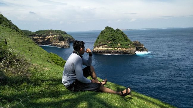
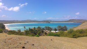
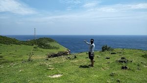
Currently TWA Gunung Tunak is a recently popular destination discussed among travelers starting in early 2014. Gunung Tunak Nature Park is located in south Lombok in Mertak village, Pujut sub district, Central Lombok district from Kuta beach to the east is approximately 23 km to arrive at the view point on a rocky cliff containing limestone rock.

At the police guard gate there are written provisions that must be obeyed

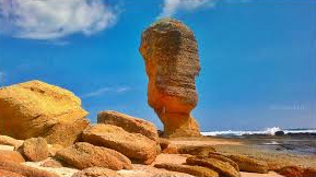
Especially after being visited by our homeland celebrity Nadien Chandrawinata in March 2015 posing to sit on the edge of the rock while facing a lump of rock soaring in the middle of the sea approximately 50 meters from the edge of the cliff then posted on Facebook, this path is still in the direction of Kuta beach but at the intersection of Kuta roundabout we have to get away as far as 10 km so we will arrive at the T-junction to Bumbang beach with the characteristic of an orange gate.

Not far from the gate there is a flat tube on the corner of the intersection written “CASH MOUNTAIN NATURAL TOURISM” and 2 km directions to the Bumbang beach but what we mean is now broken and replaced with pictures of hotel resort ads, after turning right following the path Asphalt arrived at the beach, the view of cages belonging to the Marine Cultivation Center (BBL) was seen scattered like dirt trapped in Bumbang bay.

Mount Tunak is part of the east side of the cape

Then turn left following the asphalt road, it is very disturbing for the sights of a very beautiful tourist attraction if there are no cages scattered in the Bumbang bay but from the other side to increase fishery yield is very potential and good, we do not have to be selfish judging all things from our respective point of view especially looking at the bad side without having to consider the other side of goodness, bad for tourism but good for fishery products.

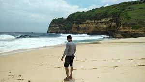
From the end of the asphalt road that ends on the coast but now the pavement body has reached the Gate of Gunung Tunak Nature Tourism Gate, besides that, a building beside the gate is a building belonging to BKSDA (Natural Resources Conservation Center) which consists of buildings for information center, meeting hall building and there are several guest house rooms.

After arriving at the beach there was no shade where we had to park except to the lower end of the cliff

From this gate there is a dirt road to get to the location of Mount Tunak Natural Tourism Park which covers an area of ​​312 hectares, according to information from the staff of the Gunung Tunak TWA guard in Polsus (Forest Police) uniforms in May 2018 Gunung Tunak will be paved to the location of the beach object.

It’s a pity that there are obstructions made of bamboo for withdrawal of IDR 5,000 entrance tickets for one person from the IDR 5,000 admission price for one person. It seemed strange because there was no official ticket and no ticket window at that time turned out to be illegal payments from villagers who claimed that visitors pass through the front yard of their house, then after we break through the coast as far as about 1 km meters there is another ticket window that has no waiting (at that time) and what we mean is the gate or tour gate of TWA Gunung Tunak which I discussed above and January 28, 2018 yesterday I paid the entrance ticket here Rp 7,500 / person because of Sunday.

To go to the core object we must climb the cliff towards the direction of the tower location as shown in this picture

If we pay Rp. 5,000 / person for the entrance ticket, we also have to go in to get to the location by crossing the asphalt road construction with gravel studded material. When I visited the second time at the end of January 2018 the road to the beach was flooded with mud and muddy. there were several visitors who turned unable to cross it.

After entering the forest area that is not too wet 5 km before entering the beach location there are more officials from the forestry department with brown-green uniforms with a stretch of portal from bamboo stems and there are forestry officers guarding the location by handing in admission tickets of IDR 7,500 / person for one visitor but now it is no longer collected at this location, we only have to pay the entrance ticket at the gate that I mentioned earlier. Towards this tourist location it is strange how many locations are where the entrance ticket is drawn and which is correct?

The right side of the Teluk Tunak beach cliffs

It turned out that according to information from the forestry guard post, this is where the official temporary entrance ticket at the first location was levied, and then how could it happen like that, they said it was an extortion from the people who claimed that visitors were pursuing their yard, but that was not what we skip the coast.

With friends who love MTB bikes leave from the city of Mataram.

Ah, it seems complicated to visit this location according to the information from their forestry post guards who had previously been hostile to prohibiting entrance fees but they insisted claiming visitors went through their yard and now the location we meant was no longer there because the coastline was paved, How come the villagers want to install more portals on the asphalt road?

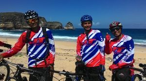
And what is strange is that the forestry police can take care of the entrance ticket to the park. We happen to come on holiday with friends from the MTB bicycle team at Rp 7,500 per person for holiday prices and Rp 5,000 for temporary holidays. foreign visitors are charged IDR 150,000 / person for holidays and Rp 100,000 / person for normal days.

The admission price is fantastic and the most expensive according to my knowledge for the cost of admission to tourism destinations on the island of Lombok, this is very unnatural but this has already been stipulated by the central government and has even been displayed in public places and there are binding provisions. at that time there were 2 French tourists who used motorbikes visiting this location because they were unable to pay the entrance fee of Rp. 150,000 / person.

We must climb the cliff on the left side to get to the tower location

Finally we proceeded towards the coast of Gunung Tunak after paying an entrance fee of Rp 7,500 / person at that time we came with a MTB bicycle, but before we saw the road to the right there was a destination to other objects also he said that was still a package with the price of the admission ticket and recently we learned from the information that people who had visited there turned out to be the destination to the Gili Penyu object as I had seen in the pictures of Lombok tourism objects.

Your visit is incomplete if it doesn’t arrive at the tower location.

Of course it is very sad because it does not match the entrance fees that we have paid, the location is very quiet and there are no supporting facilities at the time but now there are Paruga or gazebo buildings at some points and certainly in 3 points with a large size 3 x 5 meter. There were rocky ground and thorny bushes which made one of our friends leak tires due to thorns. There are even those who are tempted to not come to this location again, quite the first and the last time he said.

Closer to the tower, on a rocky cliff

Especially considering the access to this location is very unfriendly and unpleasant, but it will be different if the road is already on the asphalt in May 2018, the future discourse from the BKSDA will make the butterfly garden now realized and the building already has Butterfly Education Centers with construction of walls with walls and nets in part of the construction, will also make deer cages around the guard post but still we are pessimistic in responding to all this because the entrance ticket prices are too expensive with no facilities on the beach location. We finally turned around with disappointment until at the junction of the gate we chose the right lane to Telok Ekas on the main road and out to the main road in the village of Mujur towards the city of Praya.

Very visible iron tower looks already rust

Bukit Merese South Beach Panorama Near To Kuta

Merese Hill

Merese Hill, the meaning of the word Merese in Sasak the basic word is  which means: tasty, good, delicious, delicious. The word res itself is the language of the Sasak tribe in the southern part of Lombok because in Lombok has pronunciation parts in the mention or different words with the same meaning.

In the other part of Lombok uses another word, “maik.” means that the location intended is rightly called Merese because it is geographically located in southern Lombok, precisely east of Kuta beach which is included in the Mandalika resort area.

The bottom of the bay coast of Tanjung Aan looks like Blue Sapphire from the top of the Merese hill

The strange thing about this location is the location of the tour which is very beautiful but as if newly known, considering the beaches of Kuta, Seger beach and Tanjung Aan beach are far more popular although this location (Merese hill) is still within the “Mandalika Resort”

If you have been to Tanjung Aan, the location of this location we often see from a distance is a green rock hill that flanks the bay of Tanjung Aan in the west or right side, when we are on Tanjung Aan but we never thought that up there there was a very beautiful tourist attraction.

The other side of Merese Hill

Since many years Tanjung Aan has become a tourist destination by travel agents recently, Merese hill has become the traveler’s spotlight, why not first? Maybe the tourists who go to Tanjung Aan are part of the last visit destination.

If the guide wants to take the visitors up the Merese hill, they will lose a lot of time so that the tour is not in accordance with the travel itinerary schedule that has been set by the travel agent because they have to arrive at the hotel around the clock 5 pm.

This is the most phenomenal tree on Merese Hill and the only tree here

Why have many tourists visited Merese hill recently? Maybe after the era of smart phones mushroomed a lot of people come here for a vacation that is preceded by tourists from around Lombok itself so that the location of Merese hill is often posted on Facebook which makes many travelers become curiously or want to know and hunt for this location.

So I think personally since when is the Merese hill popular? I will answer since the mushrooming of people using smart phones, because I myself have been visiting Tanjung Aan for a few years recently. I know Merese hill after 2 years holding a smart phone.

All visitors must be willing to walk to the top of Merese hill because for 2-wheeled vehicles it seems impossible to serve this route because in addition to the steep slope also on the road many prominent stone blocks and even some loose stones means that it is impossible to see bicycles.

Except for those who want to damage a motorcycle, maybe they can or can use a motor with a certain type that is specifically for off road, such as “The Trekker. For visitors who are obese or elderly, I don’t recommend visiting this location because they have to walk up a hill that is quite high about 70 meters, besides that there are no trees except one on the path to the right that is not too shady.

After arriving at the top of Merese hill then looking behind the Tanjung Aan bay looks very beautiful.

Before reaching the top of the hill while looking towards the back of the visitors can already see the beauty of the bay of Tanjung Aan from the top of Merese hill after arriving on Merese’s ridge there are two choices to walk to the right or to the left that must visit both of them to complete know Merese hill, so if we go to the left.

Visitors will be on a hill with a view of the Seger beach and Kuta beach in the west if you walk to the left, on the hill consists of a vast expanse of grass, very green and fertile but if in the dry season these grasses will look dull and even the color will become brown if it hasn’t rained for a long time.

Stone that protrudes from the surface of the grass adorns the location

This location is still decorated with natural-looking rocks that stand out in a cluster of grasses, but unfortunately the nosy hands stain by striking and writing on the rock, in the middle of this green savanna there is the only tree where you can take shelter but unfortunately the leaves don’t too lush for shelter to avoid the heat of the sun.

Often this location is used as the background where people take pictures as a characteristic of Merese hill location and certainly in this location you will be free from the pursuit of hawkers, but there are cute kids who will a lot of help especially for taking pictures for those of you who come to this location, they are very masterful of gadget and know photography techniques, but how happy they are if they are given IDR 5,000 rewards, just count the charity.

Many sides of idolatry are presented here if we are able to go up to the left

After satisfied exploring this location in various directions, there is still another location that I mean to the left, it is far enough to go to the location, I mean it is very visible that the path to the top of the hill will waste energy which is the footpath used visitors but don’t be afraid you have to fight a little so that your visit is complete to the Merese hill.

I am sure that the breathless breath that you are exerting towards the eastern hill will pay off with the exotic view of the Tanjung Aan bay which is so charming with curved shapes decorated with the coast long white sand and land that looks green with lush coconut trees that appear faintly from a distance.

You can imagine if in the rainy season the grass in this place will be very green and very beautiful

Likewise, the headland that flanks the bay of Tanjung Aan on the east side but not as high as Merese hill looks beautiful which at the end looks on the beach of Batu Payung although it doesn’t look too clear but the physical side is still visible that towering from the distance called Batu Payung.

Headland Merese hill which is still this hill is very long so for those who like photography can explore this hill to the point where the contours are getting lower I am sure there are many good sides for photography.

Batu Payung Beach in Tanjung Aan It’s Now Collapsed

Batu Payung

Batu Payung (Umbrella Stone) ? Maybe we do not have to argue about the origin of this name because it is simple to see from the word Batu, which is certainly the form of the intended object and the word Umbrella may already be guessed because of the towering shape of the stone or the word others who experience abrasion for a long period of time until the top of this stone looks bigger than the bottom that supports it to be called Batu Payung.

Batu Payung is seen faintly on the tip of the promontory to the east from the top of Merese hill.

Although it is actually not exactly like an umbrella, but this term is easier to use to preserve the shape of this stone, besides that, we can use this stone as umbrella or shelter if the sun is very hot.

In my opinion this stone condition is very dangerous, because of the possibility of broken (it was broken) when viewed from its form which is increasingly eroded by water so that the upper load is unable to be supported by a lumpy part which is at a glance like the form of this fungus.

Alternatively, you can rent this boat without having to walk along the shoreline

This Umbrella Stone is actually popular after appearing on cigarette advertisements which took the location of shooting in Tanjung Aan which featured a beautiful appearance at a glance taken from Drown cameras until now Batu Payung has become the target of domestic tourists.

Foreign tourists and especially local visitors or Lombok people. accessing the coastal path to get to the location of the stone form of this umbrella can we also see from the top of Merese hill or from the top of the hill to the right or west which seems vague but the shape can still be recognized.

In addition, we can also visit by renting a boat at Tanjung Aan bay with a rent of IDR 250,000 for the cost of commuting with a suitable capacity to fill a boat that can be estimated at 10 people because the boat is not too big and takes 10 minutes, it is not difficult to get this service if you roam and look foreign around Tanjung Aan, there will be people who come to offer crossing services to the location of Batu Payung.

Batu Payung is located behind a hill or at the end of a hill that appears to be smearing into the sea

This beach is located not too far from Kuta beach about 5 km to the east along the beach with asphalt road which is rough and only 3.5 meters wide with a sequence across Seger beach, Tanjung Aan bay.

Then Batu Umbrella beach which is not visible from the asphalt road because the location of the mo mental stone is behind the rocky hill, to get to this path there are no signs given on the roadside.

From Tanjung Bay, you can see Batu Payung at the left end

To approach this, only the people around us can ask, but there are very few local people who flash, there are only traits of 4-wheeled ex-road that cut dry land that resembles a path to a fisherman’s hut and occasionally there are promotional banners or hotel advertisements.

Now here will be a young man who welcomes you while offering a parking ticket of Rp 5,000 for a motorcycle and Rp 10,000 for a 4-wheeled vehicle. From this parking lot, the Batu Payung object does not appear only when we ask the parking attendant with only a simple answer. pointing to the direction of the rocky and rocky coastline, while saying “there is a little way to go 1,5 km there”

We can see Batu Payung from above if we come across the top of the hill

To get to Batu Payung location, you need to be careful because you will cross slippery rock rocks because at certain times the tide causes moss on the surface of the rock, approximately after walking 10 minutes you will see Batu Umbrella as shown.

Besides, there is an alternative way up the hill but later when going down it will be a little difficult to spin a little but this is a better alternative than having to wet your feet while dragging drag to avoid the slippery parts and be careful also because there are sharp pieces of rock eroded by the waves.

No Other alternative places for shelter if the weather is very hot except only on the part of the rock that we visit, there is nothing special in this location only if for shooting it looks very unique because rarely do you know that there are stones like that but for me this form is more correct to call it rock clothes that still have hard earth elements.

From Gerbang Wisata to Batu Payung beach 1 hour 25 minute (60 km)

Where To Rent And Play Kano in Gili Trawangan

Cano Play

You can get cano rental locations on the east side of Trawangan Gili Islands

Canoeing on Gili Trawangan is not very regular, we see it only a few times when people pass by canoe either because of what, but usually this activity is often seen when the sea water conditions are calm again.

Maybe because of that reason, so seldom people canoe on Gili Trawangan but also hearing from tourists he said rental prices were too expensive.

There are two canoes which we commonly see, namely canoes for single and double canoes facilitated with paddles and jacket lifts or life jackets, the rental costs are calculated on an hourly basis.

But what is certain is the location for canoe play spots on Gili Trawangan you can get around the location of turtle breeding sites or in front of the Oda cafe which is located next to the north east coast of Gili Trawangan island or about 1 km to the north from the public port, there some canoe fruit will appear on display by propping on pine trees but this is mainly the type of puddle board while the canoe is placed on the beach.

the atmosphere of the east side of the island of Gili Trawangan, while relaxing the others while playing Cano

If you want to rent enough, you stand near the display items, then someone will come to greet you because canoe guards usually relax watching the canoe from under the spruce or in the surrounding stalls without even having to come near the canoe.

The tenants usually greet while offering rentals , but there is no price list installed at a glance, I heard that for the rental price of 150,000 / hour, the form of canoe which we commonly see here is mostly like surf boards (puddle board) but the size is very large which is facilitated with other forms of temporary paddles and life jackets there are also like canoes in general.

At first glance, it seems that most Caucasians, who are more rented compared to domestic tourists, are probably Indonesian people, most of them are afraid of black skin times? Caucasians and Caucasians enjoy this game more often they are seen standing how to use it.

While holding it in the middle, especially the transparent ones, Caucasians and Caucasians standing on the board wearing bikini clothes and rowing, there was a faint look at a rope attached to the ankle so that when the board was turned upside down or fell not far away it ran because the rope was tied ankle, the price can also change if the visit season is quiet if this problem please just bargain the price later.

Sunbathing Beach area in Gili Trawangan

Sunbathin in Trawangan


As a true traveler, wherever you want to visit wherever possible, every moment you want is recorded, at least it can be recorded by the picture of your smart phone right? No exception if you are going to visit Gili Trawangan surely you want to show that you really are on Gili Trawangan with the characteristics there are Caucasians and Caucasians again basking on the beach.

Location in front of Ombak Sunset Hotel

Well, the sunbathing location on Gili Trawangan is generally seen in front of the Horizontal pub lounge which is about 300 meters from the public port on Gili Trawangan, walking to the right because in this area it has a vast expanse of white sand, Caucasians who want to embezzle the color of the skin is where they are basking in bikini clothing to sleep on their backs while reading thick novels using a glass sun or we call black glasses.

Almost most of the sunbathers here are western or for Indonesians we call Caucasians because the color of the skin is white, if there are local or indigenous people who join here it will look strange, for Caucasians to darken the skin is their tradition while on vacation to the tropics which is sometimes their pride as a sign of returning home from the tropics because Europeans enjoy less sunlight than people who live close to the equator.

Sunbathing location on the east coast of Gili Trawangan in front of turtle breeding

Sunbathing in mini clothes for Caucasians and Caucasians is a tradition of their culture in vacation, walking in bikini clothes even when paddling a few times, but don’t get mistaken that doesn’t mean this is porn action but this is a matter of tradition and does not mean Caucasians are free to be touched because of their way or their meteoric culture, it is not for them a bitch or porn is part of their lifestyle.

When they dress like that they will be very disturbed if you glare at it especially if you dare to touch an unnatural part of the body, the Caucasians will report you to the authorities. For now the tourist visit to Gili Trawangan is very swollen in the area that I mentioned above has been unable to accommodate so many people who will bask in front of Horizon pub so now in the place I mentioned it is no longer playing set.

On the west coast of Gili Trawangan beach many foreign tourists are sunbathing sporadically, especially now that all the buildings on the beach are evicted by the district government apparatus, more and more areas are considered comfortable to relax or sunbathe, unlike before if you just sit there suddenly will come to offer food menus at quite fantastic prices.

Sunbathing location on the North coast of Gili Trawangan in front of the Bali Kana hotel.

On Gili Trawangan, although it is the largest tourism destination in the archipelago, it does not mean that Caucasians and foreigners have the freedom to carry their customs and traditions to this island because they are very good and the values ​​of social norms are still highly valued on this island. Caucasians are limited not to wander haphazardly into the village by wearing their bikinis because in every alley and entrance, a warning has been given with the prohibition against using bikini clothing into the village.

Previously the coast was dominated by business people so it did not provide space for people who just wanted to sunbathe.

Only they are given the flexibility at the beach side location, of course, especially for naked naked without clothes they are already in the path with writing on the sunbathing location not to be naked and must respect the norms of the local community especially now that it has been standing for a long time 2 mosques are quite large and wrong one is quite magnificent with modern architecture.